Nature & Location
Most of Australia’s
earthquakes are small and go unnoticed. According to research by Geoscience Australia
(GA), Australia has on average one earthquake per day - although
only measuring up to 2.0 on the magnitude scale. Australia seems to have
a high seismicity for a region that sits in the middle of the tectonic plates
and has more earthquakes that other regions that sit in middle of the plates as
well. Australia has an earthquake 6.0 or greater every 5 years. Western
Australia is a quake hotspot although Adelaide in the capital with the highest
risk of being struck. The biggest earthquake Australia has ever had was in Meeberrie, Western
Australia in 1941 measuring 7.2 on the magnitude scale.
Prediction for places in the middle of tectonic plates is next to impossible making it hard for warning and evacuation. Earthquakes in Australia can strike anywhere at anytime.
An example of this is the 1989, Newcastle Earthquake. At 10.29am on the 28th of December 1989, an earthquake shot through NSW, hitting Newcastle at a magnitude of 5.6 - it only last 5 seconds. Still to this day, it is said to be one of Australia's worst natural disasters.
*Below: A map of the 1989 Newcastle earthquake by levels of damage severity
Prediction for places in the middle of tectonic plates is next to impossible making it hard for warning and evacuation. Earthquakes in Australia can strike anywhere at anytime.
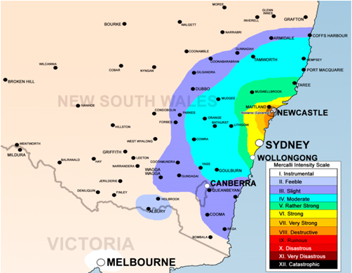
An example of this is the 1989, Newcastle Earthquake. At 10.29am on the 28th of December 1989, an earthquake shot through NSW, hitting Newcastle at a magnitude of 5.6 - it only last 5 seconds. Still to this day, it is said to be one of Australia's worst natural disasters.
*Below: A map of the 1989 Newcastle earthquake by levels of damage severity